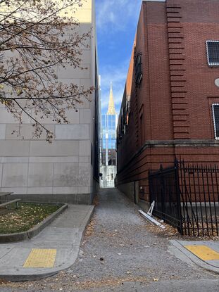
Utica Way
From Pittsburgh Streets
| Utica Way | |
|---|---|
 Utica Way seen from Winthrop Street | |
| Neighborhood | North Oakland |
| Utica Alley (until 1914) | |
This narrow alley, running from Henry Street to Winthrop Street between the Dithridge Street parking garage and a red brick electrical substation, was laid out in 1851 in a plan of lots by Edward Dithridge and Henry Reis, though that plan did not give it a name.[1] Its name was established as Utica Alley by a Pittsburgh city ordinance in 1881.[2] It became Utica Way in 1914, when another ordinance changed all alleys in Pittsburgh to ways.[3]
See also
References
- ↑ "Plan of out lots situated in the City District, being a subdivision of a part of the Fulton farm adjoining the Manor of Pittsburgh made for Dithridge & Reis." Laid out June 23, 1851; recorded Aug. 12, 1851, Plan Book 1, p. 202. Allegheny County Recorder of Deeds 3778294. [view source] dithridge-reis-plan
- ↑ "An ordinance establishing the names of avenues, streets, lanes and alleys of the City of Pittsburgh." Pittsburgh city ordinance, 1880–1881, no. 33. Passed Feb. 28, 1881; approved Mar. 4, 1881. Ordinance Book 5, p. 212. In Municipal Record: Minutes of the Proceedings of the Select and Common Councils of the City of Pittsburgh, for the Year 1880, pp. 213–234, Herald Printing Company, Pittsburgh, 1881 (Internet Archive pghmunicipalrecord1880). [view source] ordinance-1880-1881-33
- ↑ "An ordinance changing the name 'alley' on every thoroughfare in the City of Pittsburgh to 'way.'" Pittsburgh city ordinance, 1914, no. 402. Passed Nov. 10, 1914; approved Nov. 16, 1914. Ordinance Book 26, p. 360. In Municipal Record: Minutes of the Proceedings of the Council of the City of Pittsburgh for the Year 1914, appendix, p. 226, McClung Printing Co., Pittsburgh (HathiTrust uiug.30112108223899; Internet Archive Pghmunicipalrecord1914). Reprinted in the Pittsburgh Post, Nov. 23, 1914, p. 11 (Newspapers.com 86505785), and Nov. 24, p. 12 (Newspapers.com 86505809). [view source] ordinance-1914-402
