Source:Hopkins-1889-vol-1
From Pittsburgh Streets
Atlas of the City of Pittsburgh, vol. 1. G. M. Hopkins & Co., Philadelphia, 1889. http://historicpittsburgh.org/maps-hopkins/1889-volume-1-atlas-pittsburgh; included in the 1890 layer at Pittsburgh Historic Maps (https://esriurl.com/pittsburgh).
- Title page (Historic Pittsburgh 20091019-hopkins-0001)
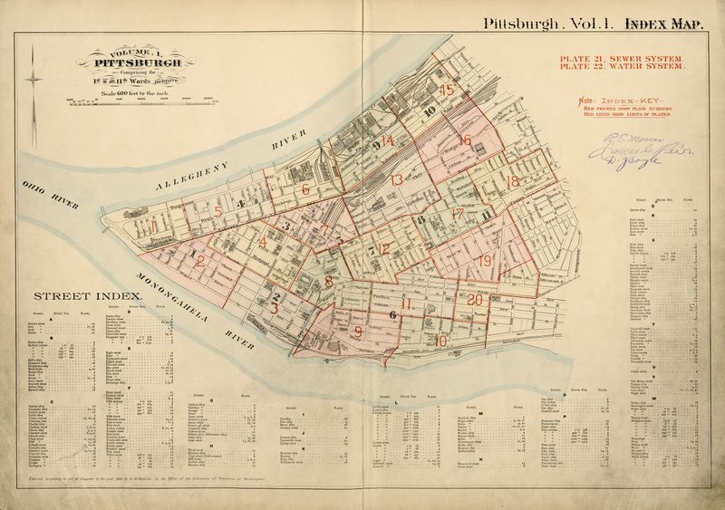
- Index map (Historic Pittsburgh 20091019-hopkins-0002)
- Plate 1: The Point below Liberty and Fourth Street (Historic Pittsburgh 20091019-hopkins-0003)
- Plate 2: Liberty to Wood, Fourth Avenue to the Monongahela (Historic Pittsburgh 20091019-hopkins-0004)
- Plate 3: Wood to Try, Fourth Avenue to the Monongahela (Historic Pittsburgh 20091019-hopkins-0005)
- Plate 4: Liberty to Grant, Fourth to Sixth Avenues (Historic Pittsburgh 20091019-hopkins-0006)
- Plate 5: Fourth to Eighth Streets, below Liberty (Historic Pittsburgh 20091019-hopkins-0007)
- Plate 6: Eighth to 11th, below Liberty (Historic Pittsburgh 20091019-hopkins-0008)
- Plate 7: Area bounded by Liberty, Sixth, and Webster Avenues and Washington Street (Historic Pittsburgh 20091019-hopkins-0009)
- Plate 8: Northwest of Grant and Fourth Avenue, lower Wylie and Forbes (Historic Pittsburgh 20091019-hopkins-0010)
- Plate 9: Bluff below Locust, Try to Magee (Historic Pittsburgh 20091019-hopkins-0011)
- Plate 10: Bluff below Locust, Magee to Miltenberger (Historic Pittsburgh 20091019-hopkins-0012)
- Plate 11: Bluff above Locust, Chestnut (Chatham Square) to Marion; lower Colwell (Historic Pittsburgh 20091019-hopkins-0013)
- Plate 12: Chatham to Fulton (Fullerton), Webster to Fifth/Clark (Historic Pittsburgh 20091019-hopkins-0014)
- Plate 13: Crawford-Roberts, Washington to Gum (Manilla), Webster to PRR (Historic Pittsburgh 20091019-hopkins-0015)
- Plate 14: Strip District, 11th to 15th (Historic Pittsburgh 20091019-hopkins-0016)
- Plate 15: Strip District, 15th to 20th (Historic Pittsburgh 20091019-hopkins-0017)
- Plate 16: Crawford-Roberts, Bedford Dwellings, Gum (Manilla) to Erin, Bedford to PRR (Historic Pittsburgh 20091019-hopkins-0018)
- Plate 17: Crawford-Roberts, Fulton (Fullerton) to Green/Granville, Centre to Bedford (Historic Pittsburgh 20091019-hopkins-0019)
- Plate 18: Crawford-Roberts, Middle Hill, Green/Granville to Kirkpatrick, Centre to Bedford (Historic Pittsburgh 20091019-hopkins-0020)
- Plate 19: Crawford-Roberts, Fulton (Fullerton) to Devilliers, Centre to Colwell (Historic Pittsburgh 20091019-hopkins-0021)
- Plate 20: Bluff, Marion to Miltenberger, Locust to Colwell; Crawford-Roberts, Dinwiddie to Devilliers, above Fifth (Historic Pittsburgh 20091019-hopkins-0022)
- Plate 21: Sewer system (Historic Pittsburgh 20091019-hopkins-0023)
- Plate 22: Water system (Historic Pittsburgh 20091019-hopkins-0024)

