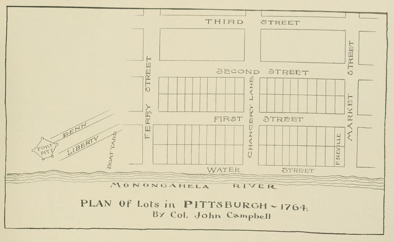
Source:Campbell
John Campbell. Plan of Lots in Pittsburgh—1764. 1764. Reproduced in William G. Johnston, Life and Reminiscences from Birth to Manhood of Wm. G. Johnston, Knickerbocker Press, New York, 1901 (Google Books N-QEAAAAYAAJ; Historic Pittsburgh 00adj9508m; Internet Archive lifereminiscence00john); in George T. Fleming, "Flem's" Views of Old Pittsburgh: A Portfolio of the Past Precious with Memories, p. 5, Geo. T. Fleming, Pittsburgh, 1905 (HathiTrust 011204797, 100770599; Historic Pittsburgh 31735056290277; Internet Archive flemsviewsofoldp00flem; LCCN 08028848); in George T. Fleming, "History told in Pittsburgh street names: Some commemorative designations have been lost, but others are still in use to recall the story of their selection: Haphazard municipal nomenclature," Pittsburgh Gazette Times, Nov. 29, 1914, sec. 5, p. 2 (Newspapers.com 85906737); in George T. Fleming, "Vickroy tells of surveying new city: Laying out of Market, Liberty and other arteries in Pittsburgh detailed: Much speculation," Pittsburgh Gazette Times, Apr. 1, 1917, sec. 5, p. 2 (Newspapers.com 85873662); in George T. Fleming, "History from an old map: Masson's map of Pittsburgh, 1805, further considered—Campbell's plan of 1764, Woods and Vickroy's complete plan of 1784—the old military plan unwillingly retained—Vickroy's deposition quoted: Pioneer names enumerated as lot owners; Historic characters recalled by names on Masson's plan—explanation of numbering of lots and some mention of freeholders—Imlay's topographical description of 1793," Pittsburgh Gazette Times, July 16, 1922, sec. 2, p. 2 (Newspapers.com 85913850); in George T. Fleming, Fleming's Views of Old Pittsburgh: A Portfolio of the Past, p. 10, Crescent Press, Pittsburgh, 1932; in George Swetnam, "Ferry Street historic, one of oldest in city: Backward switch gives recognition to man undeserving of honor," Pittsburgh Press, Nov. 25, 1954, p. 16 (Newspapers.com 149015965); in Bruce J. Buvinger, The Origin, Development and Persistence of Street Patterns in Pittsburgh, Pennsylvania, p. 21; and in Bob Regan, The Names of Pittsburgh: How the City, Neighborhoods, Streets, Parks and More Got Their Names, p. 57, The Local History Company, Pittsburgh, 2009, ISBN 978-0-9770429-7-5. This map is often called the "military plan of Pittsburgh."

