File:1845 McGowin map.jpg

Original file (1,596 × 1,412 pixels, file size: 678 KB, MIME type: image/jpeg)
Summary
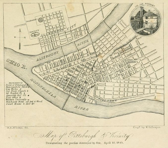
R. E. M'Gowan. Map of Pittsburgh & Vicinity: Designating the portion destroyed by fire, April 10, 1845. J. W. Cook, Pittsburgh, 1845. https://commons.wikimedia.org/wiki/File:Pittsburgh_map_1845.jpg. Published in the front matter of J. Heron Foster, A Full Account of the Great Fire at Pittsburgh, on the Tenth Day of April, 1845: With the individual losses, and contributions for relief, J. W. Cook, Pittsburgh, 1845 (Internet Archive fullaccountofgre00fost) and of O. Ormsby Gregg, Isaac Gregg, and Moses F. Eaton, Pittsburgh, Her Advantageous Position and Great Resources, as a Manufacturing and Commercial City, Embraced in a Notice of Sale of Real Estate, Johnson & Stockton, Pittsburgh, 1845 (Google Books nrJs-DDEN1sC; Historic Pittsburgh 00afu7810m). [view source] mcgowin-1845
File history
Click on a date/time to view the file as it appeared at that time.
| Date/Time | Thumbnail | Dimensions | User | Comment | |
|---|---|---|---|---|---|
| current | 12:56, 11 March 2022 | | 1,596 × 1,412 (678 KB) | Bkell (talk | contribs) | Cropped from original scan of https://archive.org/details/fullaccountofgre00fost/. |
| 09:46, 11 March 2022 |  | 1,583 × 1,255 (557 KB) | Bkell (talk | contribs) | {{Source:Mcgowin-1845}} |
You cannot overwrite this file.
File usage
The following 3 pages use this file: