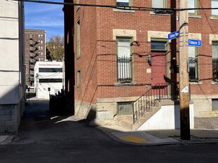
Zebina Way
| Zebina Way | |
|---|---|
 Zebina Way, looking north from Filmore Street | |
| Neighborhood | North Oakland |
| Zebina Alley (until 1914) | |
| Short Street (1866–1881) | |
| Portion | From Winthrop Street 80 feet southward |
| Origin of name | Its short length, only 80 feet |
This alley was laid out in 1851 in a plan of lots by Edward Dithridge and Henry Reis, though that plan did not give it a name.[1] Its name was established as Zebina Alley by a Pittsburgh city ordinance in 1881.[2]
This ordinance actually spelled the name Zabina, but it is alphabetized where Zebina should be, and elsewhere the ordinance lists "Florida alley, from Zebina alley to Boundary street" (today Flossie Way).[2] So it seems clear that the intended spelling was Zebina, and Zabina was merely a typo. In any case, the spelling Zebina was officially established by another ordinance in 1910.[3]
Zebina Alley became Zebina Way in 1914, when an ordinance changed all alleys in Pittsburgh to ways.[4]
The wider portion of this alley running southward from Winthrop Street was laid out in 1866 as Short Street in James McGinnis' plan of lots,[5] named for its short length, only 80 feet. It is labeled with this name in Hopkins atlases from 1898 to 1910,[6][7][8] but the 1881 ordinance listed "Zabina [sic] alley, from Henry street to Florida alley,"[2] which would have included Short Street too, implicitly making it part of Zebina Alley.
See also
- Short Street, for other streets that have had that name
References
- ↑ "Plan of out lots situated in the City District, being a subdivision of a part of the Fulton farm adjoining the Manor of Pittsburgh made for Dithridge & Reis." Laid out June 23, 1851; recorded Aug. 12, 1851, Plan Book 1, p. 202. Allegheny County Recorder of Deeds 3778294. [view source] dithridge-reis-plan
- ↑ Jump up to: 2.0 2.1 2.2 "An ordinance establishing the names of avenues, streets, lanes and alleys of the City of Pittsburgh." Pittsburgh city ordinance, 1880–1881, no. 33. Passed Feb. 28, 1881; approved Mar. 4, 1881. Ordinance Book 5, p. 212. In Municipal Record: Minutes of the Proceedings of the Select and Common Councils of the City of Pittsburgh, for the Year 1880, pp. 213–234, Herald Printing Company, Pittsburgh, 1881 (Internet Archive pghmunicipalrecord1880). [view source] ordinance-1880-1881-33
- ↑ "An ordinance establishing the names of the avenues, streets, lanes and alleys in the City of Pittsburgh." Pittsburgh city ordinance, 1909–1910, no. 716. Passed Mar. 31, 1910; approved Apr. 5, 1910. Ordinance Book 21, p. 359. In Municipal Record: Minutes of the Proceedings of the [Select and Common Councils] of the City of Pittsburgh for the Years 1909–1910, appendix, pp. 328–381, Devine & Co., Pittsburgh, 1910 (Google Books doQzAQAAMAAJ; HathiTrust uiug.30112108223832; Internet Archive Pghmunicipalrecord1909). Reprinted in the Pittsburgh Post, Apr. 29, 1910, pp. 12–16 (Newspapers.com 86616256, 86616285, 86616314, 86616333, 86616343), and Apr. 30, pp. 12–16 (Newspapers.com 86616643, 86616672, 86616694, 86616726, 86616748). [view source] ordinance-1909-1910-716
- ↑ "An ordinance changing the name 'alley' on every thoroughfare in the City of Pittsburgh to 'way.'" Pittsburgh city ordinance, 1914, no. 402. Passed Nov. 10, 1914; approved Nov. 16, 1914. Ordinance Book 26, p. 360. In Municipal Record: Minutes of the Proceedings of the Council of the City of Pittsburgh for the Year 1914, appendix, p. 226, McClung Printing Co., Pittsburgh (HathiTrust uiug.30112108223899; Internet Archive Pghmunicipalrecord1914). Reprinted in the Pittsburgh Post, Nov. 23, 1914, p. 11 (Newspapers.com 86505785), and Nov. 24, p. 12 (Newspapers.com 86505809). [view source] ordinance-1914-402
- ↑ "Plan of lots laid off for James McGinnis April 9th 1866 in East Pittsburgh: Being a subdivision of part of Reis and Dithridge's plan." Laid out Apr. 9, 1866; recorded Feb. 5, 1870, Plan Book 4, p. 5. Allegheny County Recorder of Deeds 3778780. [view source] james-mcginnis-plan
- ↑ Real Estate Plat-Book of the City of Pittsburgh, vol. 1, plate 16. G. M. Hopkins & Co., Philadelphia, 1898. http://historicpittsburgh.org/maps-hopkins/1898-volume-1-plat-book-pittsburgh-east. [view source] hopkins-1898-vol-1
- ↑ Real Estate Plat-Book of the City of Pittsburgh, vol. 1, plate 20. G. M. Hopkins & Co., Philadelphia, 1904. http://historicpittsburgh.org/maps-hopkins/1904-volume-1-plat-book-pittsburgh; included in the 1903–1906 layer at Pittsburgh Historic Maps (https://esriurl.com/pittsburgh). [view source] hopkins-1904-vol-1
- ↑ Atlas of Greater Pittsburgh, plate 9. G. M. Hopkins & Co., Philadelphia, 1910. http://historicpittsburgh.org/maps-hopkins/1910-atlas-greater-pittsburgh; 1910 layer at Pittsburgh Historic Maps (https://esriurl.com/pittsburgh). [view source] hopkins-1910
