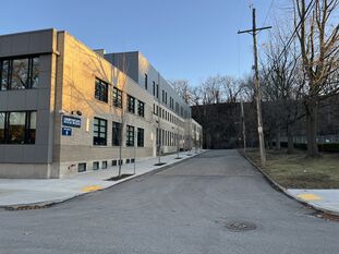
Bank Street
| Bank Street | |
|---|---|
 Bank Street from Ridge Avenue. | |
| Neighborhood | Allegheny West |
| Origin of name | North bank of the Allegheny and Ohio Rivers |
| Bank Lane (until ca. 1860) | |
| Origin of name | North bank of the Allegheny and Ohio Rivers |
| School Street (1860s) | |
| Origin of name | First Ward Public School House |
Bank Street is a short, unmarked street south of the intersection of Ridge Avenue and West Ohio Street, alongside the Allegheny County Medical Society building.
Bank Lane was one of the original lanes of the "Reserve Tract of Land Opposite Pittsburgh" (as the North Side was originally called), running along the north bank of the Allegheny and Ohio Rivers except for a rectangular diversion around the mouth of a creek about where PNC Park is today.[1][2]
By 1850, this rectangular detour had blended into the street grid of Allegheny. That year a plan of lots was laid out on the old seminary grounds on the hill where the CCAC campus is today. This plan included a north–south street in line with the western side of the Bank Lane rectangle; since it extended that street, it was given the name Bank Lane too.[3][4][5] Part of this extension eventually became today's Bank Street.
About 1860 the various parts of Bank Lane were renamed; the western side of the rectangular detour was changed to School Street (today Scotland Street). The 1862 map of S. N. and F. W. Beers applies this name to the northern extension of the street too (modern Bank Street).[6] This name referred to the First Ward Public School House, which stood at the northwest corner of School Street and Rebecca Street (today Reedsdale Street).[4]
The 1872 Hopkins atlas restricts the label School Street to the southern portion only, leaving the northern part (today's Bank Street) unlabeled.[7] The 1882 Hopkins atlas shows School Street south of Martin Street (modern Martindale Street) and Bank Street to the north, though only the northernmost segment of Bank Street is drawn as a completed street.[8]
The modern name Bank Street preserves the name of Bank Lane even though today's street is far from the riverbank and perpendicular to it. See also Diamond Street, which also preserves the name of an old street that did not originally include the modern street, and is far away from the source of its name (Market Square).
See also
- Bank Street (disambiguation) and School Street, for other streets that have had those names
References
- ↑ Reserve Tract of Land Opposite Pittsburgh. L. J. Richards & Co., 1863. Historic Pittsburgh DARMAP0084. Reproduced in Dan Rooney and Carol Peterson, Allegheny City: A History of Pittsburgh's North Side, pp. 2–3, University of Pittsburgh Press, Pittsburgh, 2013, ISBN 978-0-8229-4422-5 (LCCN 2012047727). A variation entitled City of Allegheny 100 Years Ago is reproduced in Walter C. Kidney and Arthur P. Ziegler, Jr., Allegheny, p. 2, Pittsburgh History & Landmarks Foundation, 1975 (LCCN 75-43276), and in Allegheny City Society, Allegheny City, 1840–1907, pp. 10–11, Images of America, Arcadia Publishing, Charleston, S. C., 2007, ISBN 978-0-7385-5500-3 (LCCN 2007927944). [view source] reserve-tract
- ↑ Jean Barbeau and Lewis Keyon. Map of Pittsburgh and Its Environs. N. B. Molineux, Pittsburgh, 1830. Historic Pittsburgh DARMAP0576; https://digitalcollections.nypl.org/items/36c3ab00-57aa-0136-8f4f-08990f217bc9. [view source] barbeau
- ↑ "Plan of Seminary Lots as laid out by Committee on City Property and adopted in Councils Jan. 20, 1850." Recorded Sept. 6, 1850, Plan Book 1, pp. 180–181. Allegheny County Recorder of Deeds 3778266. [view source] seminary-plan
- ↑ 4.0 4.1 R. E. McGowin. Map of the Cities of Pittsburgh and Allegheny and of the Boroughs of South-Pittsburgh, Birmingham, East-Birmingham, Lawrenceville, Duquesne & Manchester etc. Schuchman & Haunlein, Pittsburgh, 1852. https://collections.lib.uwm.edu/digital/collection/agdm/id/32269. [view source] mcgowin-1852
- ↑ The Cities of Pittsburgh and Allegheny, with Parts of Adjacent Boroughs, Pennsylvania. 1855. Historic Pittsburgh DARMAP0089; https://www.davidrumsey.com/luna/servlet/detail/RUMSEY~8~1~1688~130047; https://collections.lib.uwm.edu/digital/collection/agdm/id/32240; 1855 layer at Pittsburgh Historic Maps (https://esriurl.com/pittsburgh). In George W. Colton, Colton's Atlas of the World: Illustrating physical and political geography, J. H. Colton & Co., New York, 1856 (https://www.davidrumsey.com/luna/servlet/view/search?q=Pub_List_No%3D0149.000). [view source] colton
- ↑ S. N. & F. W. Beers. Map of Allegheny Co., Pennsylvania. Smith, Gallup & Hewitt, Philadelphia, 1862. LCCN 2012592151; https://collections.lib.uwm.edu/digital/collection/agdm/id/31783; 1862 layer at Pittsburgh Historic Maps (https://esriurl.com/pittsburgh). [view source] beers
- ↑ Atlas of the Cities of Pittsburgh, Allegheny, and the Adjoining Boroughs, pp. 72–73. G. M. Hopkins & Co., Philadelphia, 1872. http://historicpittsburgh.org/maps-hopkins/1872-atlas-pittsburgh-allegheny; 1872 layer at Pittsburgh Historic Maps (https://esriurl.com/pittsburgh). [view source] hopkins-1872
- ↑ Atlas of the Cities Pittsburgh and Allegheny, plate 30. G. M. Hopkins & Co., Philadelphia, 1882. http://historicpittsburgh.org/maps-hopkins/1882-atlas-pittsburgh-allegheny; 1882 layer at Pittsburgh Historic Maps (https://esriurl.com/pittsburgh). [view source] hopkins-1882
